Trail Mountain bike La Faurie - aureille - col montbrand - col st andré - Photo

aureille - col montbrand - col st andré

© OpenStreetMap contributors
Length
Length
23 km
Max alt
Max alt
1459 m
Uphill gradient
Uphill gradient
920 m
Km-Effort
Km-Effort  
35 km
Min alt
Min alt
848 m
Downhill gradient
Downhill gradient
922 m
Boucle
Boucle
Yes
Creation date :
2021-08-09 14:13:41.312
Updated on :
2021-08-09 17:05:07.58

(0 Reviews)

Mountain bike
Mountain bike
2h14
Difficulty : Easy

Scan this QR Code to open this trail in the SityTrail application

FREE GPS app for hiking

Logo SityTrail SityTrail

IGN / Geographical institutes

Download SityTrail from the App Store Download SityTrail from Google Play

Logo SityTrail SityTrail World

The world is yours!

Download SityTrail from the App Store Download SityTrail from Google Play Download SityTrail on Huawei AppGallery

About

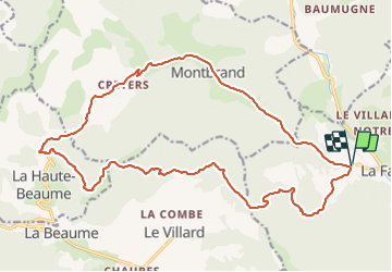
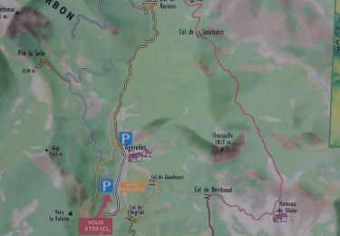
Trail Mountain bike of 23 km to be discovered at Provence-Alpes-Côte d'Azur, Hautes-Alpes, La Faurie. This trail is proposed by jcpistono.

Description

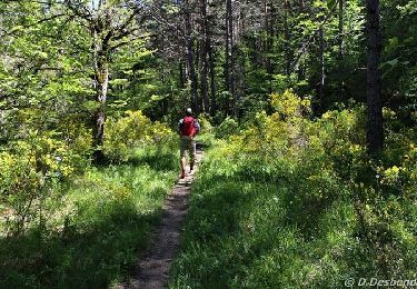
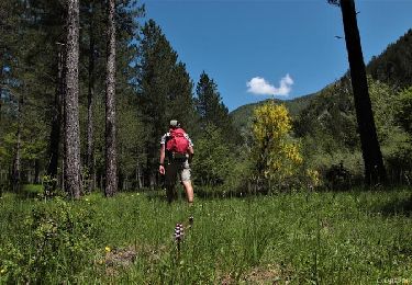
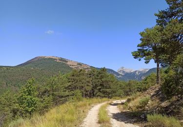
montee jusqu au col de la haite beaume sur route revetue - le reste sur chemin
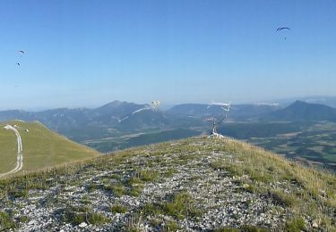
23km 920mdev - facile vttae  - tres jolis panoramas - quelques descentes raides - montee courte mais tres pentue avant clos chouvin

Elevation profile

Positioning

Country:
France
Region :
Provence-Alpes-Côte d'Azur
Department/Province :
Hautes-Alpes
Municipality :
La Faurie
Location:
Unknown
Start:(UTM)
716597 ; 4938623 (31T) N.

Trails nearby

Trail Walking La Faurie - R40   Les Marmites du Diable - Photo
Walking
GUIDE+

Walking

Medium
(6)
La Faurie, Provence-Alpes-Côte d'Azur, Hautes-Alpes, France
5.9 km | 10.4 km-effort
2h 7min
Yes
Trail Walking Aspres-sur-Buëch - R42   La Longeagne - Photo
Walking
GUIDE+

Walking

Very easy
(1)
Aspres-sur-Buëch, Provence-Alpes-Côte d'Azur, Hautes-Alpes, France
7.1 km | 11.2 km-effort
2h 23min
Yes
Trail On foot Montbrand - 9587037(1) - Photo
On foot
GUIDE+

On foot

Easy
Montbrand, Provence-Alpes-Côte d'Azur, Hautes-Alpes, France
3.5 km | 4.6 km-effort
1h 2min
Yes
Trail On foot Aspres-sur-Buëch - 9587028 - Photo
On foot
GUIDE+

On foot

Easy
Aspres-sur-Buëch, Provence-Alpes-Côte d'Azur, Hautes-Alpes, France
3.4 km | 5.3 km-effort
1h 12min
Yes
Trail Mountain bike Aspres-sur-Buëch - Gorges de l'Agnielle - Photo
Mountain bike
jeanboulay

Mountain bike

Medium
Aspres-sur-Buëch, Provence-Alpes-Côte d'Azur, Hautes-Alpes, France
12 km | 16.7 km-effort
2h 25min
Yes
Trail Mountain bike Saint-Pierre-d'Argençon - HA J3 long - Photo
Mountain bike
thierryd

Mountain bike

Very easy
(4)
Saint-Pierre-d'Argençon, Provence-Alpes-Côte d'Azur, Hautes-Alpes, France
34 km | 42 km-effort
2h 45min
No
Trail Walking La Faurie - SityTrail - SityTrail - La Vallette - Agnielles - Marmites du Diable - Photo
Walking
kurt-vh

Walking

Very difficult
La Faurie, Provence-Alpes-Côte d'Azur, Hautes-Alpes, France
15.6 km | 28 km-effort
6h 15min
Yes
Trail Walking La Beaume - Ranc de Chamoussière - Crête de la Longeagne - Photo
Walking
PapouBertrand

Walking

Very difficult
La Beaume, Provence-Alpes-Côte d'Azur, Hautes-Alpes, France
12.9 km | 23 km-effort
5h 17min
Yes
Trail Walking Aspres-sur-Buëch - Montagne Saint-Apôtre  - Photo
Walking
PapouBertrand

Walking

Very difficult
Aspres-sur-Buëch, Provence-Alpes-Côte d'Azur, Hautes-Alpes, France
9.9 km | 19.4 km-effort
5h 17min
Yes


Close
My subscriptions